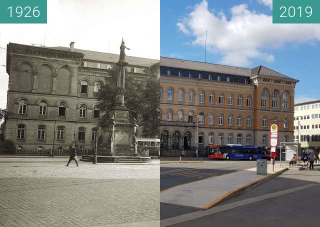
Die Aufnahme, die Lichtenberg vermutlich im Auftrag der Auer-Gesellschaft, Berlin (siehe die Gaslampen im Bild oben) gemacht hat, zeigt den Straßenverlauf der Johannisstraße vor dem Kreuzungsbereich mit Johannisfreiheit (links, hinter der Kirche) und Süsterstraße in Richtung Rosenplatz. Aufgrund des gewählten Standortes ließ sich die Reihe der über der Straßenmitte montierten Gaslampen eindrucksvoll dokumentieren. Die Johanniskirche, nach dem Dom die älteste Kirche Osnabrücks und zusammen mit einem Kollegiatstift und einer Lateinschule 1011 gegründet, bildete den Nukleus der Osnabrücker Neustadt. 1256 erfolgte die Grundsteinlegung für den heute existierenden Kirchenbau. 1292, nach sechsunddreißig Jahren Bauzeit, konnte die Kirche geweiht und in der ersten Hälfte des 14. Jahrhunderts vollendet werden. 1251 wurde das neue Johannistor erwähnt, ein Indiz dafür, dass spätestens zu diesem Zeitpunkt von einem befestigten Areal auszugehen ist, das sich womöglich von der Johanniskirche aus südlich bis zum heutigen Petersburger Wall erstreckte und gleichsam den Kern der Neustadt darstellte. Nach dem Zusammenschluss von Alt- und Neustadt (1307) entstand eine gemeinsame Befestigung, 1478 sicherte die Stadt das Johannistor durch weitere Befestigungen. Die Johannisstraße erstreckte sich vom Johannistor im Süden aus bis zur „Alten Pforte“ am Neumarkt, wobei der Abschnitt zwischen Neumarkt und der Johanniskirche auf der Katasterkarte Reinholds von 1790 noch mit „Neustädter Straße“ bezeichnet ist. Vieles spricht dafür, dass der Straßenverlauf Teil der Nord-Süd-Verbindung war, die zur Zeiten der Stadtgründung bereits existierte. Auf Lichtenbergs Fotografie präsentiert die Johannisstraße sich als belebte Geschäftsstraße (mit freundlicher Genehmigung des Museums Industriekultur).
The photograph, which Lichtenberg probably made on behalf of the Auer Society, Berlin (see the gas lamps in the picture above), shows the course of the Johannisstraße in front of the intersection with Johannisfreiheit (left, behind the church) and Süsterstraße in the direction of Rosenplatz. Due to the chosen location, the series of gas lamps mounted above the middle of the street was impressively documented. The St. John's Church, after the cathedral, the oldest church in Osnabrück and together with a collegiate and a Latin school founded in 1011, formed the nucleus of Osnabrück Neustadt. 1256 was the laying of the foundation stone for the existing church today. In 1292, after thirty-six years of construction, the church was consecrated and completed in the first half of the 14th century. In 1251 the new Johannistor was mentioned, an indication that at the latest at this time of a fortified area is to go out, which possibly extended from the St. John's Church south to today's St. Petersburg wall and represented as it were the core of the new town. After the merger of Old and New Town (1307) was a common fortification, 1478 secured the city the Johannistor by further fortifications. The Johannisstraße stretched from the Johannistor in the south to the "Old Gate" on Neumarkt, where the section between Neumarkt and the Johanniskirche on the cadastral map of Reinhold from 1790 is still called "Neustädter Straße". There is much to suggest that the road was part of the north-south connection that existed at the time of the founding of the city. On Lichtenberg's photography, the Johannisstraße presents itself as a lively shopping street (courtesy of the Museum Industriekultur).